Coastal Resilience Planning
We completed coastal resilience plans to study and address coastal flooding from sea level rise and storms for all 47 miles of Boston's coastline.
Page Sections
As part of the Climate Ready Boston initiative, the Coastal Resilience Solutions plans presented coastal resilience strategies for each of Boston's five coastal neighborhoods, including Charlestown, Dorchester, Downtown/North End, East Boston, and South Boston. Together, the plans create a vision for the future of the Boston coastline that reduces coastal flood risk, enhances the city's natural ecosystems, and improves connectivity, accessibility, and recreation along the waterfront. These planning processes laid the groundwork for action that the City is now taking.
Please visit the Coastal Resilience Implementation webpage to learn more about the status of implementing projects that were identified in the plans.
Stay Connected
Sign up to receive updates from the Environment Department:
READ THE PLANS
Coastal Resilience Solutions for East Boston & Charlestown Phase I
The Phase I plan was completed in 2017 and studied the waterfront from Sullivan Square to the Boston Autoport in Charlestown, and the waterfront from Logan Airport to Chelsea Creek in East Boston.
Coastal Resilience Solutions for East Boston & Charlestown Phase II
The Phase II plan was completed in 2022 and studied the waterfront from the Boston Autoport to the Charles River Dam in Charlestown, and the waterfront from Chelsea Creek to Wood Island Marsh in East Boston.
Coastal Resilience Solutions for Downtown and North End
The Downtown and North End plan was completed in 2020 and studied the waterfront from the Charles River Dam to the Fort Point Channel.
Coastal Resilience Solutions for South Boston
The South Boston plan was completed in 2018 and studied the waterfront from the Fort Point Channel to Moakley Park.
Coastal Resilience Solutions for Dorchester
The Dorchester plan was completed in 2020 and studied the waterfront from Dorchester Bay to the Neponset River.
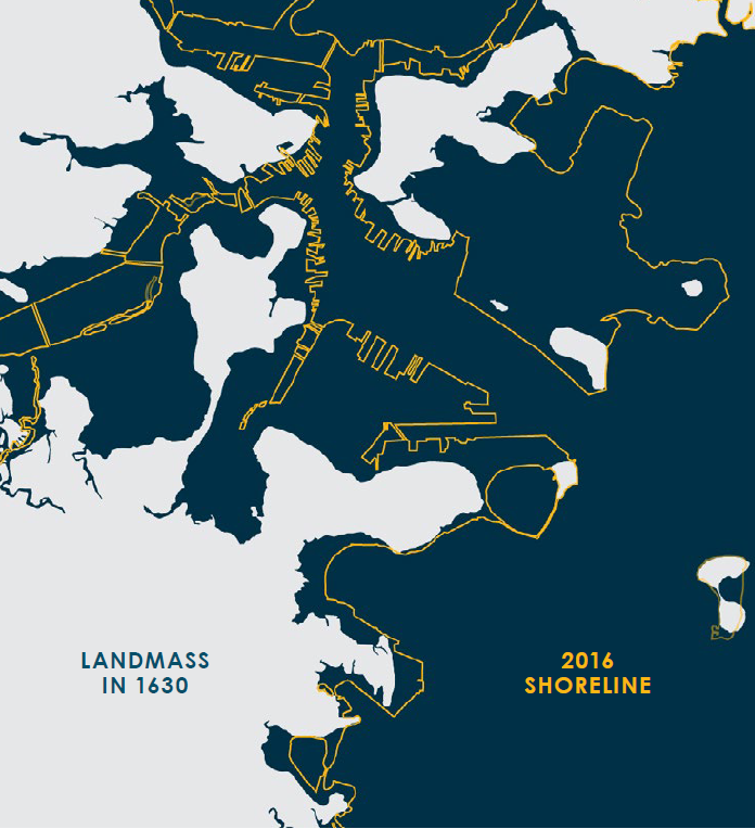
BOSTONS'S HISTORIC COASTLINE
The history of landmaking is part of what makes Boston so vulnerable to sea level rise and coastal flooding. As early at 1722, colonists started to change the natural outline of Boston by using landfill to create new space for shipping facilities, rail infrastructure, development. and more. By the turn of the 19th century, Boston’s landfilling project had changed the shape of the coastline almost in its entirety. Neighborhoods like the Back Bay, Seaport, Logan Airport, and even sections of downtown are all part of this filled-in territory.
Today, about one-sixth of Boston sits on landfill. People built new land by filling in the spaces between wharves or building out into salt marshes and tidal flats, and usually constructed the new land right above the historic high tide line. Much of that created land is vulnerable to coastal flooding now that climate change is causing sea-level rise around Boston and coastal storms are becoming more frequent and intense.
To learn more about Boston's historic coastline, visit the Norman B. Leventhal Map and Education Center at the Boston Public Library.
Coastal Flood Risk
Coastal Flood Risk
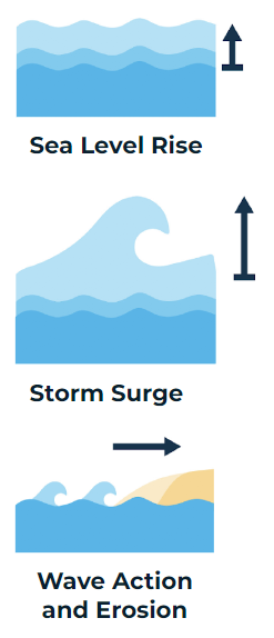
What are the types of coastal flood risk?
- Sea Level Rise refers to the rise in sea level over time relative to the land at a given location, primarily due to heat-trapping greenhouse gases that are absorbed by the ocean. As this heat is absorbed, ocean temperatures rise, polar ice melts, and water expands.
- Storm Surge refers to the abnormal rise in sea level during a storm, primarily due to a coastal storm's winds pushing water onto the shore. Storm surge is measured as the height of water above the normal predicted tide. The height of the surge depends on the intensity and speed of the coastal storm.
- Wave Action and Erosion refers to the process by which local sea level rise, strong wave action, and coastal flooding wear down or carry away rocks, soils, and/or sands along the coast, causing coastal erosion.
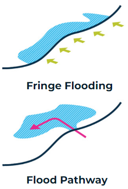
How and where does flooding occur?
- Fringe flooding impacts areas directly along the waterfront as water levels rise above the ground elevation. This causes coastal flooding along the waterfront.
- Flood pathways impact areas both directly along the waterfront and inland areas as water enters through low-lying areas on the waterfront and flows inland. This causes coastal flooding to enter a community and reach homes, businesses, infrastructure, and more.
How often will coastal flooding happen?
Coastal flooding impacts depend on the size and severity of the storm that causes the flooding, as well as the timing of when that storm arrives along the coast.
- A storm with a higher probability of occurring is likely to happen more frequently but result in less flooding. For example, a winter nor'easter may have a 5-10% chance of occurring in a given year.
- A storm with a lower probability is likely to happen less frequently but result in more severe flooding. For example, a severe winter nor'easter or a hurricane may have a 0.1-1% chance of occurring in a given year.
Coastal flooding from storms and high tides will increase over time due to sea level rise. All of Boston's coastal resilience plans developed strategies that are designed for a 1% annual chance storm with sea level rise projections for 2070.
The City of Boston refers to the Massachusetts Coast Flood Risk Model (MC-RFM) for the best available data for sea level rise projections over time, flood extents, and depths of flooding. For additional information about this model, please see the MC-FRM Modeling Overview and Frequently Asked Questions document.
Coastal Resilience Planning Process
Coastal Resilience Planning Process
What is coastal resilience?
Resilience is generally defined as the ability of a system (such as a city) to prepare for, withstand, and recover quickly from a disaster. Coastal Resilience is the ability of a community to adapt and respond to the chronic stresses and acute shocks resulting from climate change, specifically sea level rise and coastal storms.
Why is coastal resilience planning important?
Before we can take action to address coastal flooding, we need to understand where we are vulnerable, who and what is at risk, and what our adaptation options could be. Coastal resilience planning is important because it lays the groundwork for the actions Boston must take to protect its communities from current and future flood risk.
What are examples of coastal resilience strategies?
To protect Boston from coastal flooding and build a resilient coastline, we need to raise the elevation of waterfront land to prevent floodwaters from overtopping the land and impacting communities, infrastructure, open spaces, and more. The type of coastal resilience strategy that could be built depends on the existing conditions of the waterfront in a given location. Some examples of strategies included in Boston's coastal resilience plans are:
- Raised Harborwalk: Raising waterfront pathways, such as Boston's Harborwalk, can block flooding by increasing the elevation along the waterfront to keep water from overtopping the land and flowing inland. This strategy can create waterfront access or preserve existing waterfront access, and integrate trees, shade structures, and stormwater management.

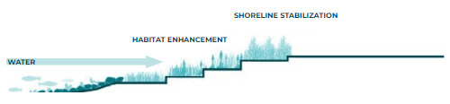
- Nature-Based Solutions: Nature-based solutions refer to a range of solutions that use natural systems (or features that mimic them) to reduce flood risk and provide other environmental and social benefits. These can include restoring or enhancing existing ecosystems, like salt marshes, or installing new features, such as living shorelines.
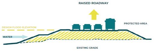
- Raised Roadways: Raising roadways for flood protection means elevating the roadway from its existing grade to a new grade above anticipated flood levels. This approach can serve multiple benefits such as keeping transportation infrastructure dry during floods, maintaining evacuation routes and access to emergency services, and serving as coastal flood protection for inland communities.
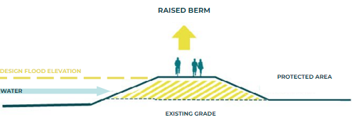
- Raised Berms: Berms are mounds of earthen material that slope up and down on either side. Berms can be integrated into waterfront parks, along beaches, and more. In some cases, the top of berms can be wide enough to provide public access to and along the waterfront, creating places for communities to gather while also providing flood protection.
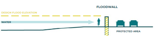
- Floodwalls / Seawalls: Floodwalls/seawalls are specially engineered walls made of concrete, steel sheet piles, or other materials designed to prevent flooding. These are usually used in locations where space is very limited and other options cannot be implemented due to existing buildings and other infrastructure that are close to the waterfront.
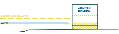
- Building Adaptation: B uilding adaptation measures occur at the building or site scale. These can include elevating the structure, utilizing deployable perimeter or entrance flood barriers, filling in basements, and using wet or dry flood-proofing. The Coastal Flood Resilience Design Guidelines include guidance for how to adapt different types of buildings that are found in Boston.
What does the coastal resilience planning process include?
Each coastal resilience plan involved multiple steps to assess a neighborhood's coastal flood risk and determine how to adapt the waterfront to protect the community from current and future flooding.
- Identify the location and timing of coastal flood risk: The plans studied where flooding is likely to take place in a given area, how flood risk may evolve over time between present-day through 2070, and what is at risk, such as residences, businesses, critical infrastructure (i.e. trains, rail yards, roads, tunnels, etc.), critical facilities (i.e. hospitals, fire stations, police stations, etc.), community assets (i.e. schools, community centers, libraries, etc.), parks and open spaces, natural areas, and more.
- Engage community members and stakeholders: Each plan involved engaging with community members, non-profits/community-based organizations, business owners, private landowners, and City, State, and Federal agencies to learn about their priorities and concerns and to identify opportunities and constraints to inform coastal resilience strategies.
- Develop coastal resilience strategies for vulnerable areas of the waterfront: For each vulnerable area, the City worked with technical experts to evaluate and determine the preferred coastal resilience strategies that could effectively prevent or reduce coastal flooding while also providing multiple benefits for the community. Co-benefits could include tree canopy, green infrastructure, multi-modal transportation improvements, ecological restoration opportunities, new waterfront access, and more.
- Create an implementation roadmap: Each plan included an implementation roadmap that outlines when each coastal resilience strategy needed to be constructed to reduce coastal flooding and next steps for advancing each project, such as presenting cost estimates, funding opportunities, design/engineering considerations, permitting pathways. Together, the implementation roadmaps enable the City to prioritize the implementation of projects over time.
Planning to Implementation
Since completing our coastal resilience planning, we have shifted our focus to advancing near-term priority projects beyond planning and into implementation. Our goal is to construct these priority projects that are targeted for around 2030 to address the most critical flood risk across all five of Boston's coastal neighborhoods. The implementation process involves multiple steps, as described below. Community and stakeholder engagement takes place throughout every step.
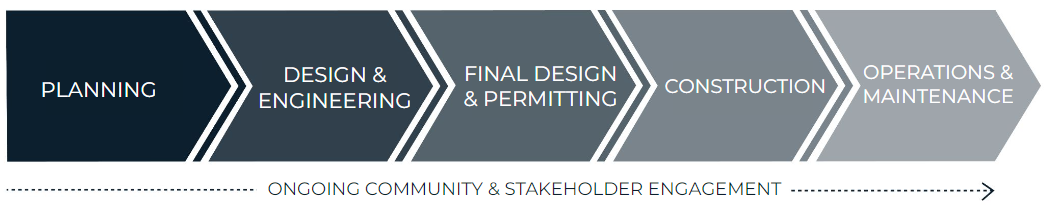
- Planning creates the conceptual design for a strategy and outlines key criteria to be refined during later phases of work.
- Design & Engineering includes refining the conceptual strategy through site investigations (such as land surveys), engineering assessments, and detailed design drawings.
- Final Design & Permitting includes the development of final engineering and design drawings, final cost estimates, and permitting the project through local, State, and Federal regulatory agencies.
- Construction delivers the design as a finished project for the community’s use of and benefit.
- Operations & Maintenance includes the necessary efforts to maintain a state of good repair.
For more information about the coastal resilience implementation progress and how you can get involved in active projects, please visit our Coastal Resilience Implementation webpage.
PAST ENGAGEMENT
Recordings of public meetings that were held virtually during the coastal resilience solutions planning processes are available on the Environment Department's Youtube. Additionally, physical copies of each plan are available at Boston Public Library branches in Charlestown, Downtown/North End, South Boston, Dorchester, and East Boston.
REPORT TRANSLATIONS
With support from the City of Boston's Office of Language and Communications Access (LCA), we strived for language accessibility throughout the coastal resilience solutions planning processes in each neighborhood. Based on LCA's Annual Demographic Data Report, we provided translation and interpretation in the top non-English languages spoken in that neighborhood. This includes:
- Translated outreach and engagement materials, such as flyers, social media content, public notices, surveys, meeting presentations, and more.
- Live, simultaneous interpretation at public meetings.
Please find available translations of the coastal resilience plans below:
